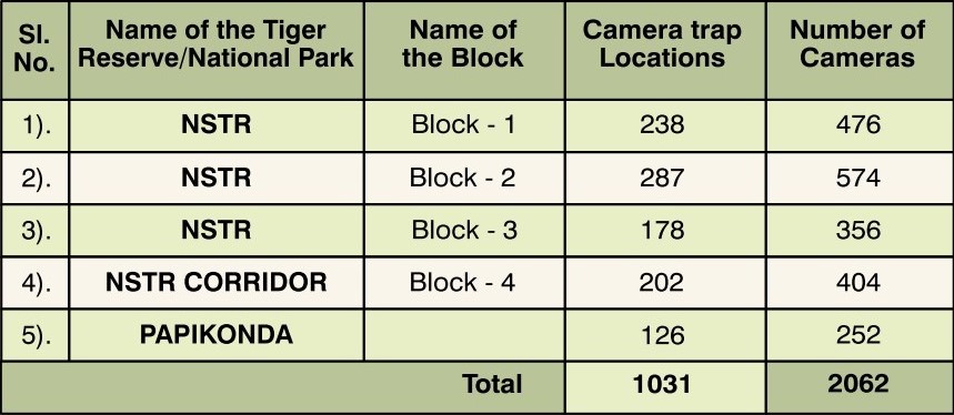
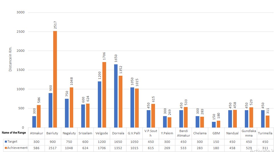
Wildlife Monitoring

Tiger Monitoring

Tiger monitoring is of utmost importance as it helps in assessing the number of tigers and other species, and also their movement patterns, state of health, sex, age etc., and will help in combating poaching and conserving the habitat.

Primarily, it occurs through 2 methods –  1) through Pugmarks    2) through camera traps

There will be basecamps in strategically important areas and the Protection watchers who are mostly from Chenchu tribes, patrol the area and record all the data – direct sightings, indirect sightings and other observations in an Android app named- “M-Stripes” [ Monitoring System for Tigers – Intensive Protection and Ecological Status] by N.T.C.A- National Tiger Conservation Authority.

The camera traps are generally of 20Mega pixels specification, and generally one paid of camera traps are placed per 2Sq.km grid. They’re placed for around 40-45 days and they capture photographs whenever any movement is detected by the internal sensors.

All the data thus received will be analysed on monthly basis, and these inputs will help in framing management plan, and gives us an idea regarding which locations are better to take up works related to habitat improvement – grassland management, soil & moisture conservation works – constructing check dams & rock fill dams, where the protection has to be strengthened etc.,

Thus, tiger monitoring forms an important base for tiger conservation plan.

Estimation of Individual Tigers

The pugmarks of tiger serve the purpose for tracking, identification of sexes, age and census.

The freshness of the marked trail of pugmarks indicates the time and the direction of the animal’s movement.

The foot prints of male tiger are wider and squarish, while that of the tigresses are more rectangular. The pugmark of one tiger is different from that of another.

Normally, the impressions of the hind feet alone are visible because in a normal gait, the hind paws are placed very close to over the impression vacated by the fore feet on the same side.

Only when the tiger moves faster than normal pace whereby the hind feet overshoot the fore feet mark, impression of all the four feet can be seen.

Screenshot_5

Pugmark Method

  • Front pugs are larger than hind pugs.
  • In a front pug, the forwardmost points of the two middle toes are almost at the same level.
  • In hind paws, the forward most points of the two middle toes are distinctly at different levels.
  • In male tigers, the Pugmark Breadth (PMB) of the front pug is mostly greater than its Pugmark Length (PML).
  • Since front pugs are used for killing prey, injuries if any, are sustained on front paws. Wherever existing, these may be visible on front Pugmarks and may serve as a conclusive identification feature of a specific animal.

Camera Trap Method

Capturing the Images

Two automatic cameras are placed on either side of the trail in each selected location to photograph either flank of a Tiger for proper individual identification.

Each camera trap image is given a unique number and all locations are plotted on the map to organize the data generated by each camera trap.

Identification of Individuals

Tigers have different stripe patterns even on both the flanks of the same animal, like fingerprints of humans. All Tigers can be individually identified based on stripe pattern.

After capturing the images, identification of individual Tigers and estimation of Tiger Population is done by using the WILD-ID Software. The stripe pattern is extracted by the software from each image and compared against all others to give unique count of individual Tigers.

Block Number 

District

Division

Range

Block-I

Nandyal & Prakasam

Atmakur & Markapur

Atmakur, Nagaluty, Srisailam & Dornala

Block-II

Nandyal & Prakasam

Atmakur, Markapur, Nandyal & Giddalur

Bairluty, Velgode, Dornala, Nandyal, GBM, Bandi Atmakur, Chalama, Gundlakamma & Turimella

Block-III

Prakasam & Palnadu

Markapur

G.V. Palli, Y.Palem & V.P.South

Corridor

Nandyal, Prakasam & Kadapa

Nandyal, Giddalur, Kadapa & Proddatur

Rudravaram, Chalama, Giddalur, Gundlakamma, Ontimitta, Siddavatam, Kadapa, Rayachoti, Badwel, Onipenta & Porumamila

Statement showing the details of Block wise Camera Trap Locations and Camera Traps during the year 2021-2022

Status of Phase –IV implementation during 2020-21

The Phase-IV monitoring for 2020-21 was completed in four Blocks i.e., (Block-I), (Block-II), (Block-III) of NSTR and Corridor (Block-IV)

Sl. No

Activity

Time line

Block-I

(161 Locations)

Block-III

(152 Locations)

Block-II

(234 Locations)

Corridor (Block-IV)

(150 Locations)

1

Commencement of camera trapping

10-11-2020

19-01-2021

15-03-2021

15-05-2021

2

Data collection of 1st round (After 20 days)

29-11-2020

10-02-2021

03-04-2021

04-06-2021

3

Removal of cameras from field (After 45 days)

20-12-2020

05-03-2021

30-04-2021

29-06-2021

4

Data submission

10.01.2021

28.03.2021

20.05.2021

Under progress

M-STrIPES (Monitoring System for Tigers - Intensive Protection & Ecological Status)

Monitoring System for Tigers – Intensive Protection and Ecological Status (M-STrIPES) is a software-based monitoring system launched in Nagarjunasagar Srisailam Tiger Reserve by the Wildlife Institute of India (WII) in collaboration with National Tiger Conservation Authority (NTCA)

Aim:

Analysis of Patrol data received from the Field staff of all Ranges in Nagarjunasagar Srisailam Tiger Reserve generating Tabular, Graphical and Spatial reports after entering data into the MSTrIPES software.

Objectives:

The Park manager can have a brief idea about their jurisdiction through the reports generated like:

  • The Patrolling effort of Field staff in the respective Ranges
  • Human Impact Index Report indicating the Human presence, Cattle grazing, Fires and NTFP collection etc.,
  • The patrolling routes surveyed by the field staff in their beats
  • The comparison of patrolling intensity in all Ranges of the Tiger Reserve
  • The distribution of Carnivores and Herbivores through direct and indirect evidences can be viewed on spatial map
  • The Ecological module on the other hand enable to understand the vegetation in the Tiger Reserve over the years


Collection of M-STrIPES:

MSTrIPES  consists  of  three  components :

  1. Data Collection  by  Field  Staff

  2. Data  Entry  &  Storage

  3. Analysis  and  Interpretation (Numerical and Graphical) at desired Spatial temporal scales.

The patrolling component of this  program gives  spatial  coverage  and  intensity  of  patrol  effort  across  the  protected area while ecological component monitors the status of habitat and fauna.


Maps and Reports:

The software has built-in GIS based reporting tool. The reports have been divided into two categories: Spatial Analysis and Non-Spatial Analysis

Spatial Analysis

Non-Spatial Analysis

Foot Patrolling report March, 2021 & April, 2021 in NSTR

Foot Patrolling during March, 2021

Division

Target

Achievement

% of achievement

1) Atmakur

4000

5777

144

2) Markapur

3475

3626

104

3) Nandyal

930

952

102

4) Giddalur

1395

1073

77

Total:

9800

11428

117

Foot Patrolling during April, 2021

Division

Target

Achievement

% of achievement

1) Atmakur

3750

6482

172

2) Markapur

3450

3251

94

3) Nandyal

1350

1454

108

4) Giddalur

900

840

93

Total:

9450

12027

127

Foot Patrolling during April, 2021

Foot Patrolling

Atmakur

Markapur

Target

4185

3100

Achievement

2843

2745

%

68

89

TIGER SIGHTINGS

Range wise foot Patrolling Effort for the month of April, 2021 in NSTR

Photos pertaining to Patrolling done by field staff during the month of April, 2021 in NSTR from M-STrIPES Monitoring